Category:Maps of British Columbia
Jump to navigation
Jump to search
Provinces and territories of Canada: Alberta · British Columbia · Manitoba · New Brunswick · Newfoundland and Labrador · Nova Scotia · Ontario · Prince Edward Island · Quebec · Saskatchewan · Northwest Territories · Nunavut · Yukon
Wikimedia category | |||||
| Upload media | |||||
| Instance of | |||||
|---|---|---|---|---|---|
| Category combines topics | |||||
| British Columbia | |||||
province of Canada  someja da satełite in disenbre     | |||||
| Instance of | |||||
| Named after |
| ||||
| Location | Canada | ||||
| Located in or next to body of water | |||||
| Capital | |||||
| Basic form of government |
| ||||
| Legislative body |
| ||||
| Executive body |
| ||||
| Official language | |||||
| Currency | |||||
| Head of state |
| ||||
| Head of government |
| ||||
| Inception |
| ||||
| Highest point |
| ||||
| Population |
| ||||
| Area |
| ||||
| Replaces |
| ||||
| Different from | |||||
| Maximum temperature record |
| ||||
| Minimum temperature record |
| ||||
| official website | |||||
 | |||||
Subcategories
This category has the following 24 subcategories, out of 24 total.
!
D
- Maps of Dixon Entrance (11 F)
F
- Maps of the Fraser River (25 F)
G
- Maps of Garibaldi Volcanic Belt (11 F)
H
- Maps of Haro Strait (5 F)
- Maps of Hecate Strait (5 F)
I
K
- Maps of Kananaskis Country (8 F)
L
- Maps of the Lynn Canal (11 F)
M
N
- Nootka Tribal Territories (14 F)
P
- Maps of Penticton (2 F)
S
V
Media in category "Maps of British Columbia"
The following 103 files are in this category, out of 103 total.
-
1903 Alaska boundary dispute.png 538 × 538; 16 KB
-
Admiralty Chart Catalogue 1967 Page 095 Index Q1.jpg 8,566 × 6,847; 10.88 MB
-
-
Alaska boundary dispute.jpg 1,184 × 1,096; 438 KB
-
AmtrakCascadesDiner.JPG 2,448 × 3,264; 1.97 MB
-
Areas Reporting Land Pollution to the NPRI.jpg 600 × 464; 177 KB
-
BC blank 3.png 713 × 698; 51 KB
-
BC blank.png 713 × 698; 60 KB
-
BC Elevation (no legend).svg 750 × 643; 4.21 MB
-
BC Elevation.svg 1,050 × 699; 4.2 MB
-
BC Ferries Zone Five.png 874 × 790; 1.22 MB
-
BC Ferries Zone Four.png 576 × 790; 807 KB
-
BC Ferries Zone One.png 852 × 790; 1.04 MB
-
BC Ferries Zone Three.png 844 × 790; 1.11 MB
-
BC Ferries Zone Two.png 1,002 × 790; 1.13 MB
-
BC Interior (39th Parl).png 293 × 446; 10 KB
-
BC Population Density 2021.svg 1,120 × 746; 312 KB
-
BC Rail map.png 373 × 634; 41 KB
-
BC School Sports Zone Map (Current).jpg 2,550 × 3,300; 600 KB
-
Bcbattleground.PNG 741 × 956; 29 KB
-
Bcmap.png 373 × 634; 24 KB
-
Bcproposalmap.jpg 800 × 606; 166 KB
-
Bear Mountain map - panoramio.jpg 4,000 × 2,992; 2.08 MB
-
BlueOutlineBritishColumbia.png 940 × 899; 26 KB
-
British Columbia 2006 population density.PNG 561 × 526; 101 KB
-
British Columbia Food Bank Locations.png 816 × 1,056; 915 KB
-
British Columbia Köppen.png 5,400 × 6,300; 766 KB
-
British Columbia Locator Map.PNG 634 × 511; 24 KB
-
British Columbia map el.jpg 1,419 × 1,733; 386 KB
-
British Columbia municipalities.png 984 × 844; 46 KB
-
-
Britsih Columbia outline.PNG 806 × 611; 36 KB
-
Brytyjska kolumbia.png 354 × 541; 88 KB
-
Bulkley Valley-Stikine 1999.png 807 × 606; 17 KB
-
Bulkley Valley-Stikine 2001.PNG 807 × 606; 17 KB
-
Canada BC lakes map.png 948 × 1,004; 145 KB
-
-
Carte baie Desolation fr.png 1,425 × 882; 310 KB
-
Carte baie Knight.png 1,332 × 869; 349 KB
-
Carte populations salish de la cote.png 1,120 × 590; 186 KB
-
Census divisions BC.png 561 × 526; 123 KB
-
West Coast of North America satellite orthographic.jpg 384 × 1,000; 91 KB
-
West Coast of North America satellite orthographic.png 383 × 1,000; 467 KB
-
Colony of British Columbia Map.png 1,041 × 899; 477 KB
-
Dawsoncreek-bc.png 373 × 634; 109 KB
-
Delta South 2001 2nd place.PNG 807 × 606; 24 KB
-
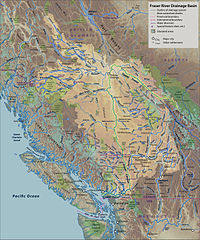
Fraser River Basin Map.jpg 2,719 × 3,260; 8.29 MB
-
Fraser Valley (41st Parl).png 477 × 563; 16 KB
-
FraserRiverBritishColumbia Location.png 458 × 339; 14 KB
-
FSJ Taylor outlining areas.png 815 × 675; 691 KB
-
Gulf Islands map.png 770 × 669; 288 KB
-
Highway of Tears Corridor.png 767 × 508; 123 KB
-
Hudson's Hope BC outline.png 754 × 580; 25 KB
-
Juan de Fuca unmarked without border ja.png 604 × 411; 499 KB
-
Juan de Fuca unmarked without border.png 604 × 411; 500 KB
-
Juan de Fuca unmarked.png 604 × 411; 514 KB
-
Kelowna British Columbia Canada street map.svg 4,606 × 6,571; 6.42 MB
-
Kettle-River-Range NASA-MODIS 11Aug2001.jpg 1,586 × 984; 874 KB
-
Kootenay & Kootenai River map.png 794 × 683; 129 KB
-
Langley Township ALR Map (August 2012).png 865 × 1,172; 497 KB
-
LangleyBCArea.png 460 × 580; 19 KB
-
Little Shuswap Lake Band map.png 1,045 × 768; 1.29 MB
-
Map - sd 19 - revelstoke.jpg 1,275 × 1,650; 162 KB
-
Map Chilkoot Trail NPS.jpg 935 × 1,484; 1,022 KB
-
Map, Haisla, Kitimat, Kitamaat village.png 1,000 × 1,000; 856 KB
-
Mapa de area.png 886 × 495; 492 KB
-
Murrin provincial park.jpg 4,160 × 2,080; 2.23 MB
-
New Westminster—Burnaby.png 604 × 607; 73 KB
-
NH RegionMap.jpg 2,253 × 2,757; 1.33 MB
-
NWWR.png 1,030 × 536; 634 KB
-
OkanaganBC2.PNG 508 × 502; 86 KB
-
Orthographic projection centred over Prince Rupert.png 488 × 487; 21 KB
-
Pacific North Coast Integrated Management Area.png 2,430 × 2,490; 1.67 MB
-
Pacific Steamship Co Explanation of Routes, 1917 (MOHAI 14769).jpg 1,000 × 566; 98 KB
-
BC parks.png 724 × 661; 254 KB
-
Partial Map of British Columbia (with sampling locations labelled).png 693 × 1,183; 1.34 MB
-
PennyMap9.pdf 1,212 × 883; 59 KB
-
PennyMapRev.pdf 1,239 × 883; 153 KB
-
Pncima map small.jpg 300 × 344; 25 KB
-
PouceCoupe BC map.PNG 1,374 × 804; 392 KB
-
Prince Rupert Harbour.png 534 × 731; 16 KB
-
Proposed tanker routes and tanker prohibition zone.jpg 2,424 × 3,186; 2.74 MB
-
Queen Charlotte Sound map2.png 967 × 811; 224 KB
-
Routes proposées pour l'accès des pétroliers à Kitimat.png 695 × 702; 644 KB
-
Régions physiographiques de Colombie-Britannique.png 536 × 580; 71 KB
-
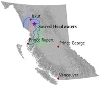
Sacredheadwatersmap.jpg 200 × 173; 7 KB
-
Secw in BC.png 2,470 × 2,000; 8.09 MB
-
Sir William Van Horne Elementary School attendance boundary.gif 305 × 400; 25 KB
-
South Asian ancestry in British Columbia.png 6,900 × 3,575; 1.17 MB
-
Stanley Map.jpg 3,138 × 856; 456 KB
-
Sun Rivers Resort Map.jpg 4,032 × 3,024; 2.76 MB
-
Tatshenshini-Alsek area Canada BC.png 502 × 377; 29 KB
-
-
The temperature and precipitation of British Columbia (1915) (14591481400).jpg 2,336 × 2,958; 839 KB
-
-
Trans Canada Trail in British Columbia.jpg 1,056 × 816; 210 KB
-
Greater Vancouver Area.png 846 × 701; 269 KB
-
GVA-map.png 846 × 701; 223 KB
-
Vancouver Island-reliefPittRiver.png 578 × 600; 643 KB
-
Westside-kelowna.png 682 × 670; 24 KB
-
Whatcomtrail2bwskagit.jpg 640 × 480; 144 KB
-
Yellow-cedar range and decline map.jpg 250 × 491; 106 KB
-
YukonWhitePassRailmap.png 396 × 481; 11 KB