Appalachian Mountains

The Appalachian Mountains (French: les Appalaches) are a large group of North American mountains. They are partly in Canada, but mostly in the United States. It stretches 2,050 mi (3,300 km) southwestward to Central Alabama in the United States [a] to the Island of Newfoundland in Canada to central Alabama in the United States.
The individual mountains average around 3,000 ft (900 m) in height. The highest is Mt. Mitchell in North Carolina (6,684 ft or 2,037m). Mt. Mitchell is also the highest point in the United States east of the Mississippi River as well as the highest point in eastern North America.
The Appalachian chain is a barrier to east–west travel. Ridgelines and valleys run north–south and travelers must climb them again and again. Only a few mountain passes run east–west. The Erie Canal was built through one of them. In most places the Appalachians are the watershed between the drainage basins of the Mississippi River and the Atlantic Ocean.

The term Appalachia is used to refer to the mountain range and the hills and plateau region around it. The term is often used to refer to areas in the central and southern, but not northern, Appalachian Mountains. These areas usually include all of West Virginia and parts of the states of Kentucky, Tennessee, Virginia, and North Carolina, and sometimes extending as far south as northern Georgia and western South Carolina, as far north as Pennsylvania, and as far west as southeastern Ohio. In 1965 the United States Congress created an Appalachian Regional Commission to include these areas and more, as far west as Mississippi.
The Appalachian Trail in the US is about 3,500 km (2,190 miles) long and goes through 14 states from Georgia to Maine.[1]
Geologic History of the range
[change | change source]
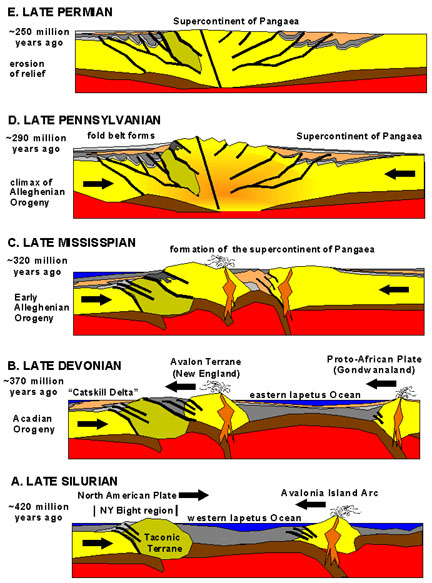
The geologic processes that led to the formation of the Appalachian Mountains started 1.1 billion years ago. The first mountain range in the region was created when the continents of Laurentia and Amazonia collided, creating a supercontinent called Rodinia. The collision of these continents caused the rocks to be folded and faulted, creating the first mountains in the region. [2]
Over time, these mountains were eroded by wind and water. The rocks that were eroded were deposited in the ocean, where they were eventually buried and turned into sedimentary rocks. These sedimentary rocks were then uplifted and folded again, creating new mountains.
This process of erosion and mountain building has repeated itself many times over the past 1.1 billion years. As a result, the Appalachian Mountains are not a single, continuous mountain range. Instead, it is a patchwork of different mountain ranges that have been created at different times.
The youngest rocks in the Appalachian Mountains are only about 250 million years old. These rocks were formed during the Alleghanian orogeny, which was the last major period of mountain building in the region.
The Appalachian Mountains are still being eroded today. Over time, the mountains will continue to wear down, and the rocks that make up the mountains will eventually be recycled back into the Earth's crust.
So, the geologic processes that led to the formation of the Appalachian Mountains started 1.1 billion years ago, but the mountains themselves are much younger. The rocks that make up the mountains are the result of millions of years of erosion, deposition, and mountain building.
References
[change | change source]- ↑ measured from Montgomery, Alabama which is at the southwestern end of the Coosa Valley, to Belle Island, Newfoundland and Labrador which is the northeastern-most extent of Newfoundland
- ↑ BBC News
- ↑ Thomas, William A.; Hatcher, Robert D. (2021), "Southern-Central Appalachians-Ouachitas Orogen", Encyclopedia of Geology, Elsevier, pp. 119–156, doi:10.1016/b978-0-08-102908-4.00183-1, ISBN 978-0-08-102909-1, S2CID 242839386, retrieved 2023-09-02
Other websites
[change | change source]